Multimediaexpo.cz je již 18 let na českém internetu !!
V tiskové zprávě k 18. narozeninám brzy najdete nové a zásadní informace.
Soubor:Earth surface NGDC 2000.jpg
Z Multimediaexpo.cz

Velikost tohoto náhledu je: 800 × 573 pixelů
Obrázek ve vyšším rozlišení (rozměr: 3 078 × 2 203 pixelů, velikost souboru: 1,86 MB, MIME typ: image/jpeg)
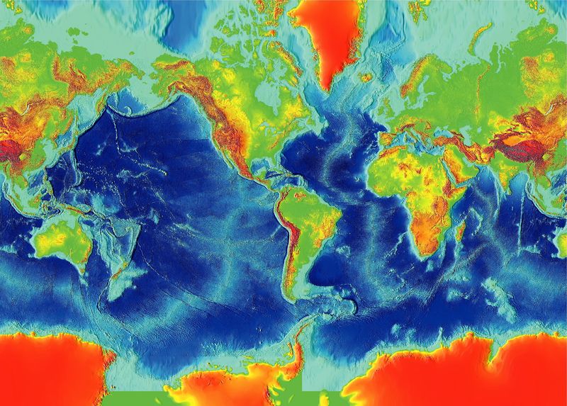
Fotografie + English: Surface of the Earth, Revised March 2000
World Data Center for Marine Geology & Geophysics, Boulder
NGDC DATA ANNOUNCEMENT NUMBER: 00-MGG-05
This image was generated from digital data bases of land and sea-floor elevations on a 2-minute latitude/longitude grid (1 minute of latitude = 1 nautical mile, or 1.853 km). Assumed illumination is from the west; shading is computed as a function of the east-west slope of the surface with a nonlinear exaggeration favoring low-relief areas. A Mercator projection was used for the world image, which spans 390° of longitude from 270° West around the world eastward to 120° East; latitude coverage is ±80°. The resolution of the gridded data varies from true 2-minute for the Atlantic, Pacific, and Indian Ocean floors and all land masses to 5 minutes for the Arctic Ocean floor.
For detailed regional maps see — http://www.ngdc.noaa.gov/mgg/image/2minrelief.html
+ pochází z Wikimedia Commons, kde má status – This image is in the public domain because it contains materials that originally came from the U.S. National Oceanic and Atmospheric Administration, taken or made as part of an employee's official duties.
Historie souboru
Kliknutím na datum a čas se zobrazí tehdejší verze souboru.
| Datum a čas | Náhled | Rozměry | Uživatel | Komentář | |
|---|---|---|---|---|---|
| současná | 14. 8. 2014, 08:34 |  | 3 078×2 203 (1,86 MB) | Sysop (diskuse | příspěvky) | (Fotografie + + pochází z Wikimedia Commons, kde má status – ) |
- Editovat tento soubor v externím programu (Více informací najdete v nápovědě pro nastavení.)
Odkazy na soubor
Na soubor odkazuje tato stránka:
