V sobotu 2. listopadu proběhla mohutná oslava naší plnoletosti !!
Multimediaexpo.cz je již 18 let na českém internetu !!
V tiskové zprávě k 18. narozeninám brzy najdete nové a zásadní informace.
Multimediaexpo.cz je již 18 let na českém internetu !!
V tiskové zprávě k 18. narozeninám brzy najdete nové a zásadní informace.
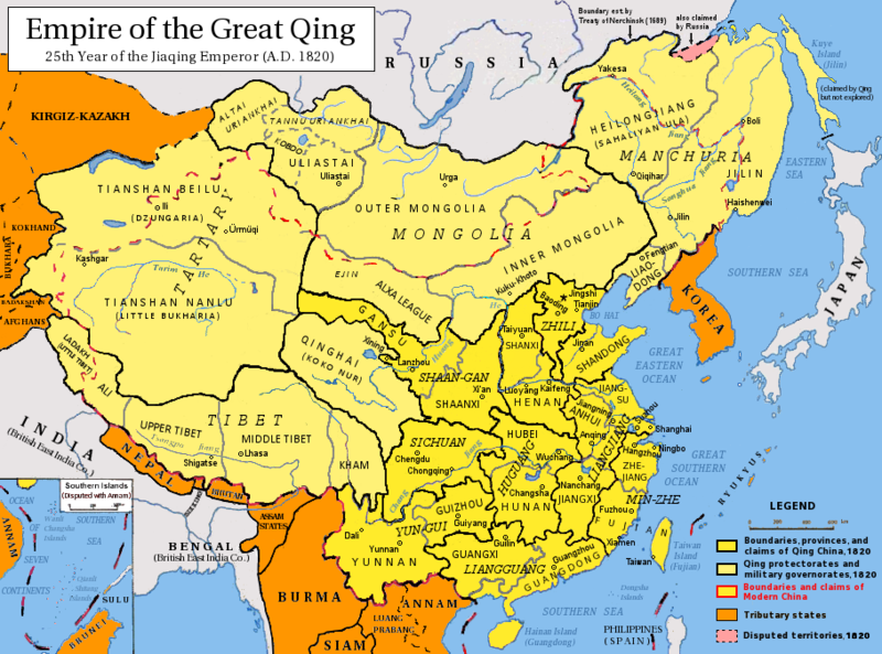
Soubor:Qing Dynasty 1820.png
Z Multimediaexpo.cz

Velikost tohoto náhledu je: 800 × 593 pixelů
Obrázek ve vyšším rozlišení (rozměr: 910 × 675 pixelů, velikost souboru: 401 kB, MIME typ: image/png)
Mapa + Description:
- English: Map of the Qing Dynasty in 1820, representing its stablized territory from 1790-1839. (Includes provincial boundaries and the boundaries of modern China for reference.) Provinces in yellow, military governorates and protectorates in light yellow, tributary states in orange.
- Adapted from File:ROC_PRC_comparison_eng.jpg and information complied from:
- http://baike.baidu.com/view/5405.htm
- http://map.huhai.net/58-59.jpg
- http://www.sina7.com/jdwh/UploadFiles_6109/200709/20070918093610860.jpg
- File China_and_Japan,_John_Nicaragua_Dower_(1844).jpg
- File Carte_generale_de_l'Empire_Chinois_et_du_Japon_(1836).jpg
- File Empire_Chinois,_Japon_(1832).jpg
- File L'Empire_Chinois_et_du_Japon_(1833).jpg
- http://city.udn.com/3011/4192243?tpno=48&cate_no=0
- http://bbs.godeyes.cn/showtopic-371673.aspx
- 中文(简体):大清嘉庆二十五年疆域图。约合1790-1839稳定时期疆域。
- 中文(繁體):大清嘉慶廿五年疆域圖。約合1790-1839穩定時期疆域。
- 日本語: 大清の嘉慶25年の疆域の図。
- 한국어: 대청제국의 가경25년의 지도.
- Tiếng Việt: Đại Thanh bản đồ (1820).
- Français: Carte du Grand Empire des Qing la 25e année Jiaqing du règne de l'empereur Qing Jiaqing (1820). Cette carte inclus les frontières provinciales et les frontières de la chine contemporaine pour référence. Les provinces sont en jaune, les gouvernorats et protectorats militaires en jaune claire, les états tributaires en orange.
- Date: 27 September 2008
- Author: Pryaltonian
+ pochází z Wikimedia Commons, kde má status – Permission is granted to copy, distribute and/or modify this document under the terms of the GNU Free Documentation License, Version 1.2 or any later version published by the Free Software Foundation; with no Invariant Sections, no Front-Cover Texts, and no Back-Cover Texts.
Historie souboru
Kliknutím na datum a čas se zobrazí tehdejší verze souboru.
| Datum a čas | Náhled | Rozměry | Uživatel | Komentář | |
|---|---|---|---|---|---|
| současná | 12. 8. 2013, 09:35 |  | 910×675 (401 kB) | Sysop (diskuse | příspěvky) | (Fotografie + Sysop + pochází z Wikimedia Commons, kde má status –) |
- Editovat tento soubor v externím programu (Více informací najdete v nápovědě pro nastavení.)
Odkazy na soubor
Na soubor odkazují tyto 2 stránky:
