V pondělí 16. září 2024 začala naše další
nová soutěž o nejlepší webovou stránku !!
Proto neváhejte a začněte rychle soutěžit o lákavé ceny !!
nová soutěž o nejlepší webovou stránku !!
Proto neváhejte a začněte rychle soutěžit o lákavé ceny !!
Soubor:Trianon map it.png
Z Multimediaexpo.cz
Větší rozlišení není k dispozici.
Trianon_map_it.png (rozměr: 655 × 500 pixelů, velikost souboru: 52 kB, MIME typ: image/png)
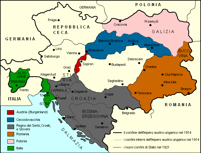
Mapa + Description:
- Italiano: Variazioni nei confini dell'Impero austro-ungarico dopo il Trattato del Trianon del 1920.
- Date: 29 February 2012, 18:36 (UTC)
- Source: This file was derived from: Trianon map hu.png
- Author: Nickshanks, from hungarian wikipedia
- derivative work: Harlock81
+ pochází z Wikimedia Commons, kde má status – Permission is granted to copy, distribute and/or modify this document under the terms of the GNU Free Documentation License, Version 1.2 or any later version published by the Free Software Foundation; with no Invariant Sections, no Front-Cover Texts, and no Back-Cover Texts.
Historie souboru
Kliknutím na datum a čas se zobrazí tehdejší verze souboru.
| Datum a čas | Náhled | Rozměry | Uživatel | Komentář | |
|---|---|---|---|---|---|
| současná | 24. 9. 2024, 12:48 | | 655×500 (52 kB) | Sysop (diskuse | příspěvky) | (Fotografie + ) |
- Editovat tento soubor v externím programu (Více informací najdete v nápovědě pro nastavení.)
Odkazy na soubor
Na soubor odkazuje tato stránka:


