V sobotu 2. listopadu proběhla mohutná oslava naší plnoletosti !!
Multimediaexpo.cz je již 18 let na českém internetu !!
Multimediaexpo.cz je již 18 let na českém internetu !!
Soubor:WWII.png
Z Multimediaexpo.cz

Velikost tohoto náhledu je: 800 × 338 pixelů
Obrázek ve vyšším rozlišení (rozměr: 1 480 × 625 pixelů, velikost souboru: 65 kB, MIME typ: image/png)
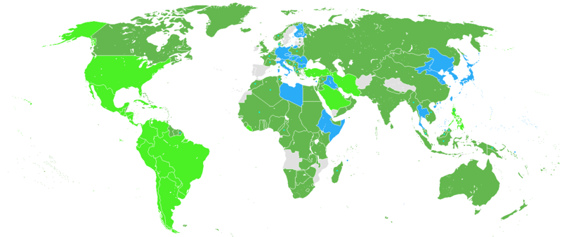
Historická mapa + English: Map of Participants in World War II:
- Dark Green: Allies before the Japanese attack on Pearl Harbor, including colonies and occupied countries.
- Light Green: Allied countries that entered the war after the attack on Pearl Harbor.
- Blue: Axis Powers and their colonies or countries that had to choose a side in order to stay independent.
- Grey: Neutral countries during WWII
- Dark green dots represent countries that initially were neutral but during the war were annexed by the USSR
- Light green dots represent countries that later in the war changed from the Axis to the Allies
- Blue dots represent countries either being conquered by the Axis Powers, becoming puppets of those (Vichy France and several French colonies).
+ pochází z Wikimedia Commons, kde má status – GNU Free Documentation License, Version 1.2 or any later version published by the Free Software Foundation; with no Invariant Sections, no Front-Cover Texts, and no Back-Cover Texts.
Historie souboru
Kliknutím na datum a čas se zobrazí tehdejší verze souboru.
| Datum a čas | Náhled | Rozměry | Uživatel | Komentář | |
|---|---|---|---|---|---|
| současná | 19. 2. 2015, 14:01 |  | 1 480×625 (65 kB) | Sysop (diskuse | příspěvky) | (Historická mapa + English: Map of Participants in World War II: * Dark Green: Allies before the Japanese attack on Pearl Harbor, including colonies and occupied countries. * Light Green: Allied countries that entered the war after the attack on Pearl Har) |
- Editovat tento soubor v externím programu (Více informací najdete v nápovědě pro nastavení.)
Odkazy na soubor
Na soubor odkazuje tato stránka:
