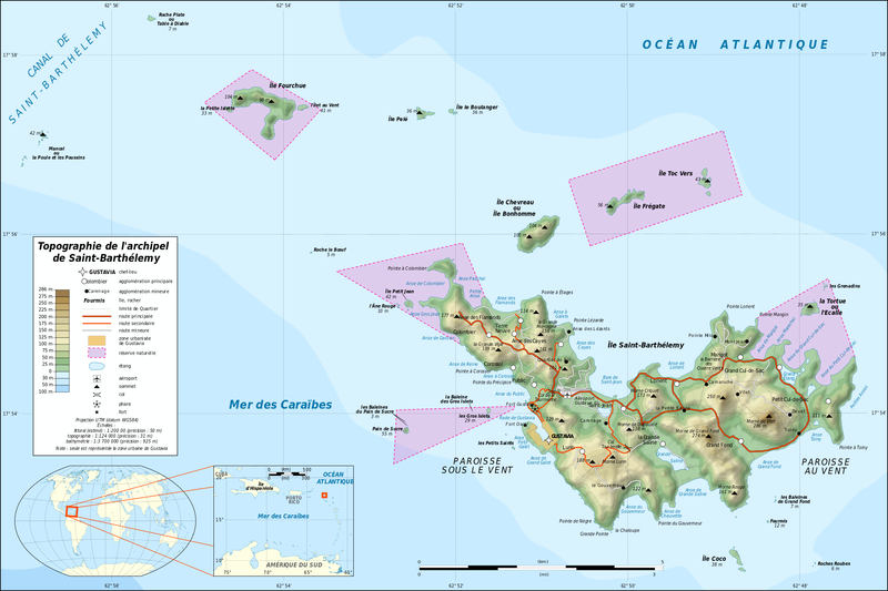
Soubor:Saint-Barthélemy Island topographic map-fr.png
Z Multimediaexpo.cz

Velikost tohoto náhledu je: 800 × 533 pixelů
Obrázek ve vyšším rozlišení (rozměr: 2 000 × 1 333 pixelů, velikost souboru: 739 kB, MIME typ: image/png)
Francouzská mapa + Français : Carte topographique en français de l'archipel de Saint-Barthélemy dans les Petites Antilles.
- Deutsch: Topographische Karte in Deutsch des Karibischen Inselarchipels von Saint-Barthélemy.
- English: Topographic map in French of the Caribbean archipelago of Saint Barthélemy.
- UTM projection, WGS84 datum, scales:
- Shorelines (estimated): 1:200.000 (precision: 50 m)
- Topography: 1:124.000 (precision: 31 m)
- Bathymetry: 1:3.700.000 (precision: 925 m)
- Date: 2010-08, updated 2015-10
- Author: Eric Gaba (fr:Sting)
+ pochází z Wikimedia Commons, kde má status – Creative Commons Attribution-Share Alike 2.0 Generic.
Historie souboru
Kliknutím na datum a čas se zobrazí tehdejší verze souboru.
| Datum a čas | Náhled | Rozměry | Uživatel | Komentář | |
|---|---|---|---|---|---|
| současná | 18. 4. 2017, 14:34 |  | 2 000×1 333 (739 kB) | Sysop (diskuse | příspěvky) | (Fotografie + + pochází z Wikimedia Commons, kde má status – Kategorie:CC fotografie ) |
- Editovat tento soubor v externím programu (Více informací najdete v nápovědě pro nastavení.)
Odkazy na soubor
Na tento soubor neodkazuje žádná stránka.
