nová soutěž o nejlepší webovou stránku !!
Proto neváhejte a začněte rychle soutěžit o lákavé ceny !!
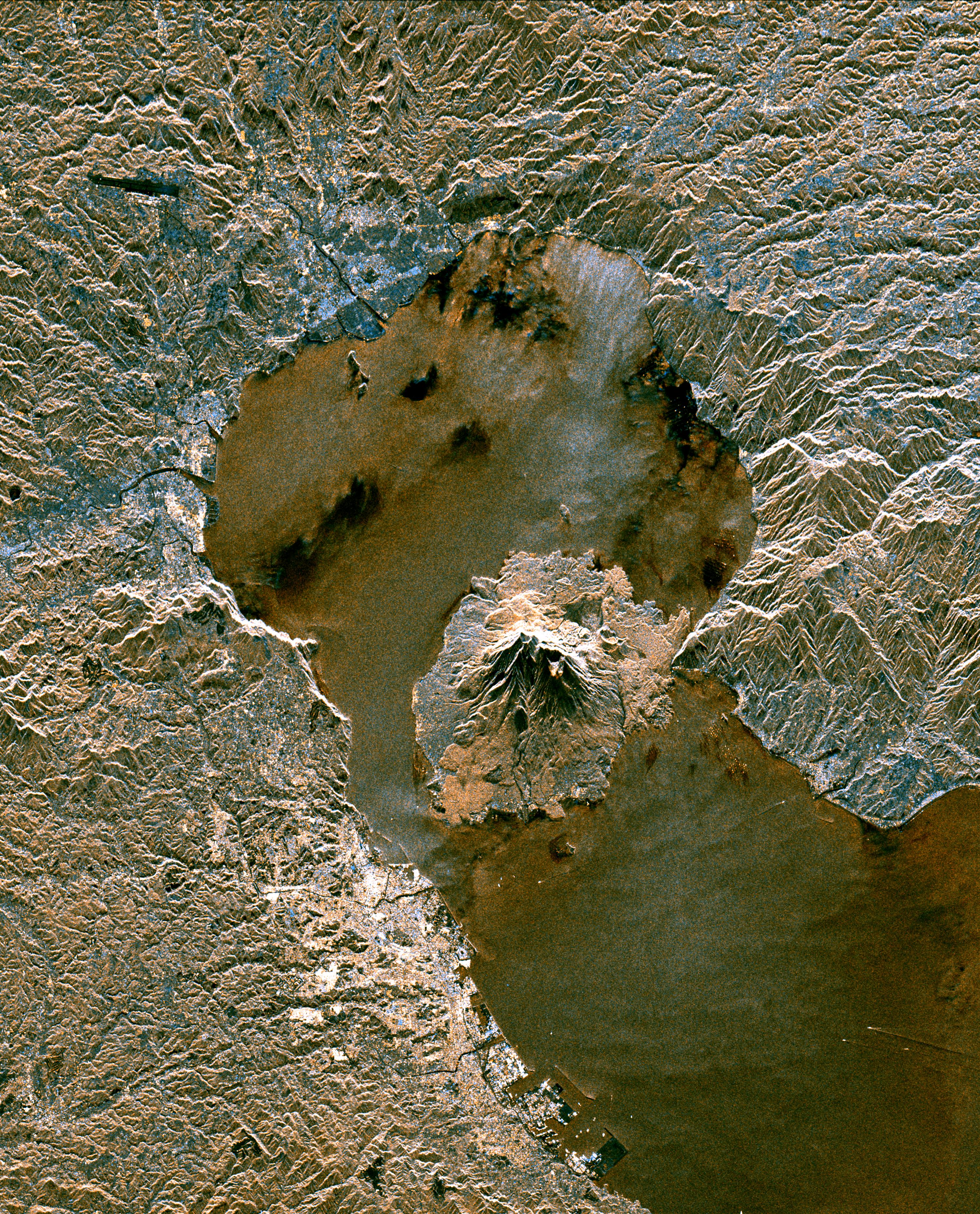
Soubor:Sakura-jima from space.jpg
Z Multimediaexpo.cz
Velikost tohoto náhledu je: 484 × 600 pixelů
Obrázek ve vyšším rozlišení (rozměr: 3 000 × 3 716 pixelů, velikost souboru: 3,15 MB, MIME typ: image/jpeg)
Fotografie + English: Sakurajima volcano from space
- Original Caption Released with Image:
The active volcano Sakura-Jima on the island of Kyushu, Japan is shown in the center of this radar image. The volcano occupies the peninsula in the center of Kagoshima Bay, which was formed by the explosion and collapse of an ancient predecessor of today's volcano. The volcano has been in near continuous eruption since 1955. Its explosions of ash and gas are closely monitored by local authorities due to the proximity of the city of Kagoshima across a narrow strait from the volcano's center, shown below and to the left of the central peninsula in this image. City residents have grown accustomed to clearing ash deposits from sidewalks, cars and buildings following Sakura-jima's eruptions. The volcano is one of 15 identified by scientists as potentially hazardous to local populations, as part of the international "Decade Volcano" program.
The image was acquired by the Spaceborne Imaging Radar-C/X-Band Synthetic Aperture Radar (SIR-C/X-SAR) onboard the space shuttle Endeavour on October 9, 1994. SIR-C/X-SAR, a joint mission of the German, Italian and the United States space agencies, is part of NASA's Mission to Planet Earth. The image is centered at 31.6 degrees North latitude and 130.6 degrees East longitude. North is toward the upper left. The area shown measures 37.5 kilometers by 46.5 kilometers (23.3 miles by 28.8 miles). The colors in the image are assigned to different frequencies and polarizations of the radar as follows: red is L-band vertically transmitted, vertically received; green is the average of L-band vertically transmitted, vertically received and C-band vertically transmitted, vertically received; blue is C-band vertically transmitted, vertically received.
- Image courtesy: NASA/JPL-Caltech
+ pochází z Wikimedia Commons, kde má status – This file is in the public domain in the United States because it was solely created by NASA. NASA copyright policy states that "NASA material is not protected by copyright unless noted".
Historie souboru
Kliknutím na datum a čas se zobrazí tehdejší verze souboru.
| Datum a čas | Náhled | Rozměry | Uživatel | Komentář | |
|---|---|---|---|---|---|
| současná | 28. 3. 2016, 10:39 | | 3 000×3 716 (3,15 MB) | Sysop (diskuse | příspěvky) | (Fotografie + + pochází z Wikimedia Commons, kde má status – Kategorie:CC fotografie) |
- Editovat tento soubor v externím programu (Více informací najdete v nápovědě pro nastavení.)
Odkazy na soubor
Na soubor odkazuje tato stránka:


