V sobotu 2. listopadu proběhla mohutná oslava naší plnoletosti !!
Multimediaexpo.cz je již 18 let na českém internetu !!
V tiskové zprávě k 18. narozeninám brzy najdete nové a zásadní informace.
Multimediaexpo.cz je již 18 let na českém internetu !!
V tiskové zprávě k 18. narozeninám brzy najdete nové a zásadní informace.
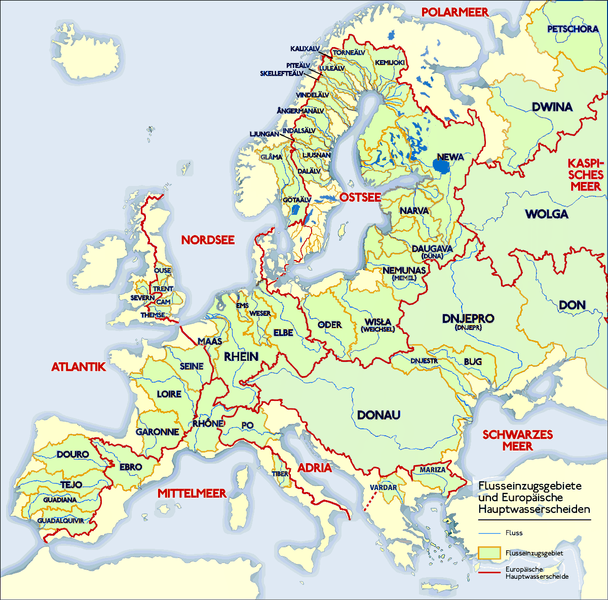
Soubor:Europäische Wasserscheiden.png
Z Multimediaexpo.cz

Velikost tohoto náhledu je: 608 × 600 pixelů
Obrázek ve vyšším rozlišení (rozměr: 1 200 × 1 184 pixelů, velikost souboru: 526 kB, MIME typ: image/png)
Mapa + Description:
- Deutsch: Grafik zeigt die Europäischen Flusseinzugsgebiete und Hauptwasserscheiden.
- Zeichnung erstellt 06/2004 von Sansculotte. Bild ist unter der Creative Commons Share Alike zur weiteren Verwendung freigegeben.
- Quellenangabe und Beleg an sansculotte@despammed.com erbeten.
- English: The map shows the European rivers' catchment areas and main watersheds.
- Chart made on 06/2004 by Sansculotte. The image is released under the Creative Commons Share Alike license for futher use.
- Reference and sources can be requested from sansculotte@despammed.com
- Français: Carte des bassins fluviaux d'Europe. Carte établie en juin 2004 par le contributeur de:Sansculotte
- Sources (!) disponibles par demande à sansculotte@despammed.com
- Fluß = River = Fleuve
- Flußeinzugsgebiet = River drainage basin = Bassin fluvial
- Europäische Hauptwassercheide = European main drainage divides (GB: watersheds)
- Date: 3 June 2004
- Author: Sansculotte
+ pochází z Wikimedia Commons, kde má status – Permission is granted to copy, distribute and/or modify this document under the terms of the GNU Free Documentation License, Version 1.2 or any later version published by the Free Software Foundation; with no Invariant Sections, no Front-Cover Texts, and no Back-Cover Texts.
Historie souboru
Kliknutím na datum a čas se zobrazí tehdejší verze souboru.
| Datum a čas | Náhled | Rozměry | Uživatel | Komentář | |
|---|---|---|---|---|---|
| současná | 24. 7. 2023, 10:47 |  | 1 200×1 184 (526 kB) | Sysop (diskuse | příspěvky) |
- Editovat tento soubor v externím programu (Více informací najdete v nápovědě pro nastavení.)
Odkazy na soubor
Na soubor odkazují tyto 3 stránky:
