Soubor:Jutland1916.jpg
Z Multimediaexpo.cz

Velikost tohoto náhledu je: 775 × 600 pixelů
Obrázek ve vyšším rozlišení (rozměr: 1 242 × 961 pixelů, velikost souboru: 299 kB, MIME typ: image/jpeg)
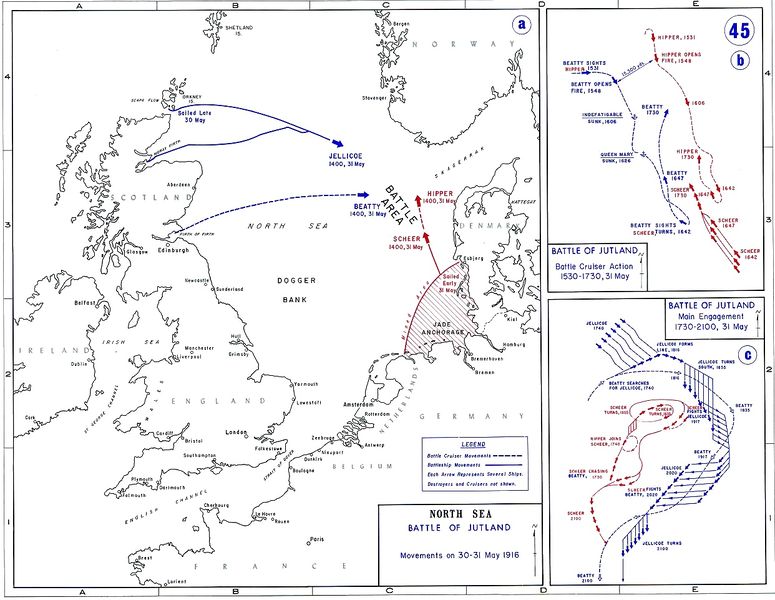
Mapa + Description: Map showing the movements of the British and German fleets during the Battle of Jutland in May 1916
- Date: Not mentioned
- Source: usma.edu
- Author: Department of History at the United States Military Academy
+ pochází z Wikimedia Commons, kde má status – This work is in the public domain in the United States because it is a work prepared by an officer or employee of the United States Government as part of that person’s official duties under the terms of Title 17, Chapter 1, Section 105 of the US Code.
Historie souboru
Kliknutím na datum a čas se zobrazí tehdejší verze souboru.
| Datum a čas | Náhled | Rozměry | Uživatel | Komentář | |
|---|---|---|---|---|---|
| současná | 13. 4. 2014, 22:31 |  | 1 242×961 (299 kB) | Sysop (diskuse | příspěvky) | (MW1.15-Fotografie) |
- Editovat tento soubor v externím programu (Více informací najdete v nápovědě pro nastavení.)
Odkazy na soubor
Na soubor odkazuje tato stránka:
