V sobotu 2. listopadu proběhla mohutná oslava naší plnoletosti !!
Multimediaexpo.cz je již 18 let na českém internetu !!
V tiskové zprávě k 18. narozeninám brzy najdete nové a zásadní informace.
Multimediaexpo.cz je již 18 let na českém internetu !!
V tiskové zprávě k 18. narozeninám brzy najdete nové a zásadní informace.
Soubor:Ottoman Provinces Of Present day Libya.png
Z Multimediaexpo.cz

Větší rozlišení není k dispozici.
Ottoman_Provinces_Of_Present_day_Libya.png (rozměr: 282 × 314 pixelů, velikost souboru: 22 kB, MIME typ: image/png)
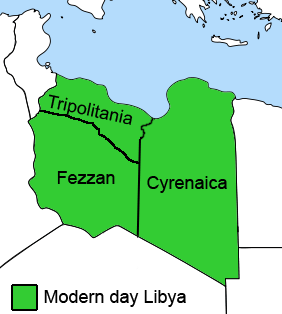
Mapa + English: The Ottoman Turks conquered the country in the mid-16th century, and the three States or "Wilayat" of Tripolitania, Cyrenaica and Fezzan (which make up Libya) remained part of their empire with the exception of the virtual autonomy of the Karamanlis. The Karamanlis ruled from 1711 until 1835 mainly in Tripolitania, but had influence in Cyrenaica and Fezzan as well by the mid 18th century.
- Date: Created April, 2008
- Author: Esemono; improved by Kirk
+ pochází z Wikimedia Commons, kde má status – I, the copyright holder of this work, release this work into the public domain. This applies worldwide.
Historie souboru
Kliknutím na datum a čas se zobrazí tehdejší verze souboru.
| Datum a čas | Náhled | Rozměry | Uživatel | Komentář | |
|---|---|---|---|---|---|
| současná | 25. 3. 2016, 17:36 |  | 282×314 (22 kB) | Sysop (diskuse | příspěvky) | (Mapa + English: The Ottoman Turks conquered the country in the mid-16th century, and the three States or "Wilayat" of Tripolitania, Cyrenaica and Fezzan (which make up Libya) remained part of their empire with the exception of the virtual autonomy of the ) |
- Editovat tento soubor v externím programu (Více informací najdete v nápovědě pro nastavení.)
