Soubor:Armenian Genocide Map-en.png
Z Multimediaexpo.cz

Velikost tohoto náhledu je: 800 × 393 pixelů
Obrázek ve vyšším rozlišení (rozměr: 2 000 × 982 pixelů, velikost souboru: 682 kB, MIME typ: image/png)
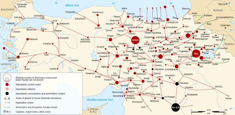
Mapa + English: Map of the Armenian Genocide in 1915.
- Each size shows a massacre. There are three types of massacre: in a control centre (red dot), in a station (pink dot), in a concentration and annihilation center (black dot). The size of the dot shows the relative number of killed Armenians.
- Each pair of swords shows an area of Armenian resistance: greater resistance (red swords) or lesser resistance (black swords). The different size of swords is to save space into the map, it means nothing.
- Dots in Black Sea representing Armenians (mainly women and children) drowned into the sea (see Armenian Genocide for references).
- Français: Carte en anglais du génocide arménien de 1915.
- Русский: Карта геноцида армян 1915 года.
- Date: 6 February 2008
- Author: Sémhur
+ pochází z Wikimedia Commons, kde má status – Creative Commons Attribution-Share Alike 3.0 Unported, 2.5 Generic, 2.0 Generic and 1.0 Generic license.
Historie souboru
Kliknutím na datum a čas se zobrazí tehdejší verze souboru.
| Datum a čas | Náhled | Rozměry | Uživatel | Komentář | |
|---|---|---|---|---|---|
| současná | 27. 4. 2017, 09:10 |  | 2 000×982 (682 kB) | Sysop (diskuse | příspěvky) | (Fotografie + + pochází z Wikimedia Commons, kde má status – Kategorie:CC fotografie) |
- Editovat tento soubor v externím programu (Více informací najdete v nápovědě pro nastavení.)
Odkazy na soubor
Na soubor odkazuje tato stránka:
